
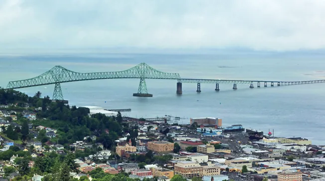
Fast Facts
- Population
- ~10,180 (2020 census)
- Typical visiting season
- Late June–Sept
- One Unusual Stat
- 4.1-mi bridge to Washington, no pull-offs
- Miles from Portland
- ~71 mi south-east (straight line)
- All-American Road
- Pacific Coast Scenic Byway - Oregon, 363 miles
What to Know Before You Arrive
Astoria was founded in 1811 by the Pacific Fur Company, a venture bankrolled by New York investor John Jacob Astor, and named for him. The fort the traders built here made this a U.S. outpost rather than a British one at a moment when that distinction was still being fought over, and the city was incorporated in 1856. According to the City of Astoria’s own history page, Astoria is the “oldest American settlement west of the Rocky Mountains” — the city’s description of itself, not a certified record.
The town nearly burned itself out of that history twice. Fires tore through downtown in 1883 and again in 1922, and both times the damage spread fast because the buildings were wood, built on pilings over marshy ground. During the 1922 fire, “frantic citizens resorted to dynamite, blowing up entire buildings to create fire stops.” What got rebuilt afterward is the brick-and-timber downtown you walk through today.
Astoria's other export is film credits. Besides The Goonies (1985), Kindergarten Cop, both Free Willy movies, Short Circuit, The Black Stallion, Teenage Mutant Ninja Turtles III, Into the Wild and Green Room all used the town as a stand-in for somewhere else. Locals mostly shrug about it; the gray skies and the working waterfront read as authentic on camera precisely because they are.
The Road Trip Stop
The Astoria Column is 125 feet tall, sits on top of 600-foot Coxcomb Hill, and does not look like anything else on this stretch of coast. It went up in 1926, paid for by the Great Northern Railway and Vincent Astor — John Jacob Astor's great-grandson — to mark the family's place in the town's history, and the entire outside is wrapped in a sgraffito frieze, nearly seven feet wide and 525 feet around, painted by Attilio Pusterla and depicting 14 major events in early Oregon history plus 18 more regional scenes. A 164-step spiral staircase runs up the inside to an open-air observation deck at the top.
Budget the time
- 30 to 45 minutes covers the climb and a lap of the frieze, longer at the top — on a clear day you can see the mouth of the Columbia and the bridge into Washington.
- Parking is $10* per vehicle and the pass is good for a year, so keep the receipt if you're coming back through. The park itself is open 5 a.m. to 10 p.m. daily.
- Pair it with the Flavel House Museum and the Oregon Film Museum downtown, both a five-minute drive away, so the hilltop view and the street-level history land in the same afternoon.
- Staircase crowding could not be confirmed. The Friends of the Astoria Column publish no crowding guidance for the 164-step climb. Their group page says the Column is a destination for thousands of cruise ship excursions and tour groups every year, and their own visitor tip points to dawn and dusk in the park. Check with the gift shop before planning around crowds.
*Fees subject to change, please check astoriacolumn.org for updated information.
Neighborhoods
Downtown / Commercial Street
The historic core, rebuilt in brick after the 1922 fire, with the old Clatsop County Jail (now the Oregon Film Museum), murals, and most of the shops and restaurants.
Uniontown & the Cannery Row waterfront
The old immigrant fishing district along the river's edge, where canneries once processed salmon around the clock; several have been converted into breweries and hotels built out over the water on pilings.
Alameda & Astoria Heights
The hillside above downtown, laced with steep streets and public staircases that substitute for sidewalks in places too steep for one; Victorian houses with river views are the reward for the climb.
Uppertown
The quieter riverfront east of downtown, home to the Columbia River Maritime Museum and the East End Mooring Basin where the riverfront trolley turns around.
The Food Stop
Fort George Brewery took over the old Lovell Auto Co. car dealership on Duane Street and has been pouring beer there for close to two decades; the flagship Vortex IPA is pushing 19 years on tap. It's at 1483 Duane Street, open daily from 11 a.m.
On Sundays from Mother's Day through mid-October, downtown's 12th Street closes for the Astoria Sunday Market, up to 150 vendors selling what they grew, caught or made, plus a food court and rotating live music from 10 to 3.
6 breweries within 10 miles of Astoria, one of them a brewpub with a kitchen.
See all 6
- Wet Dog Cafe & Brewery990 Astor St, Astoria
- Astoria Brewing Company1196 Marine Dr, Astoriaproduction site*
- Buoy Beer Company1 8th St, Astoriaproduction site*
- Fort George Brewery1483 Duane St, Astoriaproduction site*
- Hondo's Brew and Cork Pub2703 Marine Dr, Astoriaproduction site*
- Reach Break Brewing1343 Duane St, Astoriaproduction site*
*Check before you go. This list says what the source records as open and where it is — nothing more. Opening hours, whether a kitchen is serving, and whether anywhere suits your family are not in this data and change without notice. A production site may have no public room at all. Please confirm with the venue.
Brewpub locations from Open Brewery DB (MIT)
The Home Teams
No pro, minor-league or college team based in Astoria could be confirmed. Portland is about 71 miles south-east of Astoria in a straight line, and Lower Columbia College in Longview, Washington, about 41 miles east, lists baseball, basketball, softball, soccer and volleyball teams on its athletics page; check a team’s own schedule before planning around a game. On the water, the Port of Astoria’s own site says its three deep-draft terminals serve vessels “from fishing fleets to cruise ships.”
Day Trips
| Destination | Time | Distance | How we got it |
|---|---|---|---|
| Fort Clatsop, Lewis and Clark National Historical Park | 14 min | 6 mi | routed |
| The reconstructed encampment where the Lewis and Clark expedition spent the wet winter of 1805–06 before turning back east; the current replica went up in 2006 after volunteers rebuilt the previous one following a 2005 fire. | |||
| Fort Stevens State Park | 23 min | 11 mi | routed |
| A Civil War-era fort at the mouth of the Columbia that took actual enemy shellfire from a Japanese submarine in June 1942 — the only mainland U.S. military site hit in World War II — and still has the rusted skeleton of the ship Peter Iredale, wrecked on the beach in 1906, sitting on the sand. | |||
| Cannon Beachguide | 43 min | 25 mi | routed |
| Haystack Rock and the start of the northern Oregon coast's postcard stretch. | |||
| Seaside | 29 min | 17 mi | routed |
| A mile-and-a-half beachfront Promenade donated by a French immigrant mayor in 1912, and the spot where Lewis and Clark's men boiled seawater for two months to make salt for the trip home. | |||
1 of these is a place the Hub has its own guide to — marked guide and linked from the name.
Routed figures are computed over map data at free-flowing speeds, between map points rather than street addresses, so a real drive runs longer.
Distances routed by OSRM and places geocoded by Nominatim, over map data © OpenStreetMap contributors (ODbL)
Worth a Weekend
6 more Highway Heads places lie within about 180 miles of Astoria in a straight line — far enough that most are a night away rather than an afternoon.
- PortlandOregonabout 70 mi
- OlympiaWashingtonabout 75 mi
- SalemOregonabout 95 mi
- SeattleWashingtonabout 120 mi
- Space NeedleWashingtonabout 120 mi
- LeavenworthWashingtonabout 180 mi
Practical Road Trip Info
Budget one full day for Astoria itself — the Column, Flavel House, Film Museum and the waterfront — and a second if you're adding Fort Stevens or Fort Clatsop without rushing.
Pack for rain regardless of the forecast. Astoria averages about 67 inches of rain a year and stays above 80% humidity on average every month; summer is the dry exception, not the rule.
The Astoria–Megler Bridge crossing into Washington runs 4.1 miles with nowhere to pull over, so decide before you're on it; it replaced a ferry that ran from 1921 until the bridge opened in 1966.
Parking at the Column is separate from downtown. The Column’s own site says visiting the park and climbing the Column are free and that parking is $10* per vehicle, good for one year. For downtown, the City of Astoria publishes a Downtown Parking District map whose legend lists time-limited zones, and the Port of Astoria charges for parking at its East and West Mooring Basins. Current downtown street-parking rules could not be confirmed, so read the posted signs on the block.
*Fees subject to change, please check astoriacolumn.org for updated information.
The Local Debate
Family-Friendly
Oregon Film Museum
Green-screen and small-set filmmaking exhibits where visitors make their own short scenes, inside the actual jail from the movie's opening chase.
Astoria Riverfront Trolley
A slow, easy dollar ride along the water in a hundred-year-old streetcar — low effort, high payoff for younger travelers.
Fort Clatsop replica
A walk-through log fort that makes the Lewis and Clark winter feel real rather than textbook.
Haystack Rock tide pools, Cannon Beach
Twenty-five minutes away, and the closest thing to a live aquarium on this stretch of coast.
Plan Your Visit
Astoria Column
- Address
- 1 Coxcomb Drive, Astoria, OR 97103
- Hours
- Park open daily, 5 a.m.–10 p.m.; gift shop hours vary by season
- Price
- Climb is free; parking pass is $10 per vehicle, valid one year*
*Fees subject to change, please check astoriacolumn.org for updated information.
We checked fees and operating status on 2026-09-21. These change without notice — confirm with astoriacolumn.org, portofastoria.com, lowercolumbia.edu and astoria.gov the week you travel.
Sources — 33 claims, 33 checked against the source on 2026-09-21
| Claim | Source | Status |
|---|---|---|
| Founded 1811 by the Pacific Fur Company, bankrolled by John Jacob Astor; incorporated 1856 | Astoria, Oregon — Wikipedia | Checked |
| Astoria's claim to be the oldest city in Oregon and first permanent American settlement west of the Rockies | Astoria, Oregon — Wikipedia | Checked |
| Population 10,181 (2020 census) | Astoria, Oregon — Wikipedia | Checked |
| Downtown fires in 1883 and 1922; buildings on pilings; dynamite used as firebreak in 1922 | Astoria, Oregon — Wikipedia | Checked |
| Films shot in Astoria: The Goonies, Kindergarten Cop, Free Willy 1 & 2, Short Circuit, The Black Stallion, Teenage Mutant Ninja Turtles III, Into the Wild, Green Room | Astoria, Oregon — Wikipedia | Checked |
| Climate: ~67 in. annual rainfall, humidity above 80% monthly average | Astoria, Oregon — Wikipedia | Checked |
| Astoria–Megler Bridge: 4.1-mile crossing opened 1966, replaced a ferry that ran 1921–1966 | Astoria, Oregon — Wikipedia | Checked |
| Astoria Column: built 1926, 125 ft tall on Coxcomb Hill, funded by Great Northern Railway and Vincent Astor; 164-step staircase; sgraffito frieze by Attilio Pusterla depicting 14 events plus 18 scenes | Astoria Column — Wikipedia | Checked |
| Astoria Column hours (5 a.m.–10 p.m. daily), $10/vehicle parking valid one year, address 1 Coxcomb Drive | Astoria Column — official site | Checked monitored · 2026-09-21 |
| Fort Clatsop: Lewis and Clark encampment Dec 1805–Mar 1806; replica rebuilt in 2006 by ~700 volunteers after a 2005 fire | Fort Clatsop — Wikipedia | Checked |
| Fort Stevens: built 1863–64, active to 1947; shelled by Japanese submarine I-25 in June 1942; Peter Iredale wrecked 1906 | Fort Stevens — Wikipedia | Checked |
| Flavel House: built 1885 by Capt. George Flavel, Queen Anne style, 11,600 sq ft, used in The Goonies | Flavel House Museum — Wikipedia | Checked |
| Oregon Film Museum: opened 2010 in the 1913 Clatsop County Jail; Goonies jailbreak scene; Data's costume on display | Oregon Film Museum — Wikipedia | Checked |
| Astoria Riverfront Trolley: 1913 car “Old 300” from San Antonio; running in Astoria since June 1999; 3-mile route; $1 fare | Astoria Riverfront Trolley — Wikipedia | Checked |
| Garden of Surging Waves: Chinese garden at Heritage Square, groundbreaking April 14, 2012, city's bicentennial gift | Garden of Surging Waves — Wikipedia | Checked |
| Fort George Brewery: 1483 Duane Street, occupies former Lovell Auto Co. building, Vortex IPA ~19 years old, daily 11 a.m. hours | Fort George Brewery — official site | Checked |
| Astoria Sunday Market: up to 150 vendors, 12th Street downtown, Mother's Day through mid-October, Sundays 10–3 | Astoria Sunday Market — official site | Checked |
| Seaside Promenade: 1.5 miles, donated by mayor Alexandre Gilbert in 1912; Lewis and Clark salt-making camp, early 1806 | Seaside, Oregon — Wikipedia | Checked |
| Goonies house at 368 38th Street; 1,200–1,500 visitors/day in summer 2015; road closed to tours 2015; anniversary events drew 10,000–15,000 visitors | The Goonies — Wikipedia | Checked |
| Visiting the park or climbing the Column is free; parking is $10 per vehicle, good for one year; 164 steps; the site's visitor tip singles out dawn and dusk in the park (checked 2026-10-14) | Astoria Column — Know Before You Go | Checked monitored · 2026-10-14 |
| The Oregon Secretary of State's Blue Book gives Astoria's incorporation as 1856; the city's own history page states "Astoria became incorporated in 1856" (checked 2026-10-15) | Oregon Blue Book — Astoria | Checked |
| The City's own history page describes Astoria as the oldest American settlement west of the Rocky Mountains (checked 2026-10-14) | City of Astoria — History of Astoria | Checked |
| The Friends of the Astoria Column's group page calls the Column a destination for thousands of cruise ship excursions and tour groups every year; no staircase crowding guidance is published (checked 2026-10-14) | Astoria Column — Group Information | Checked monitored · 2026-10-14 |
| Wikipedia's published coordinates for Astoria, used to compute straight-line miles to Portland and Longview (checked 2026-10-14) | Astoria, Oregon — Wikipedia (coordinates) | Checked |
| Wikipedia's published coordinates for Portland, Oregon, used for the straight-line distance from Astoria (checked 2026-10-14) | Portland, Oregon — Wikipedia (coordinates) | Checked |
| Wikipedia's published coordinates for Longview, Washington, used for the straight-line distance from Astoria (checked 2026-10-14) | Longview, Washington — Wikipedia (coordinates) | Checked |
| Lower Columbia College (Longview, Washington) athletics page lists baseball, men's and women's basketball, softball, women's soccer and volleyball teams (checked 2026-10-14) | Lower Columbia College — Athletics | Checked monitored · 2026-10-14 |
| The Port's own site says its three deep-draft terminals serve vessels from fishing fleets to cruise ships (checked 2026-10-14) | Port of Astoria — home page | Checked |
| The City's Downtown District Parking Map (dated 1-29-2020) has a legend of time-limited parking zones; current street-parking rules were not confirmed (checked 2026-10-14) | City of Astoria — Downtown District Parking Map | Checked monitored · 2026-10-14 |
| The Port of Astoria has for-pay parking at the East and West Mooring Basins (checked 2026-10-14) | Port of Astoria — Parking Information | Checked monitored · 2026-10-14 |
| The City's own history page states that Astoria became incorporated in 1856 (checked 2026-10-15) | City of Astoria — History of Astoria | Checked |
| The Oregon Secretary of State's Blue Book city page lists Astoria's incorporation date as 1/18/1856 (checked 2026-10-15) | Oregon Blue Book — Astoria | Checked |
| Designated an All-American Road by the U.S. Secretary of Transportation; 363 miles in OR; FHWA suggests: Take twelve hours to enjoy the byway. Distance from this stop to the route measured against the published byway centreline on the U.S. Department of Transportation map service (geo.dot.gov), which carries no stated licence and predates the 2021 designations; the measurement is ours, the line is theirs and is not reproduced here. 0.9 miles (checked 2026-10-29) | Federal Highway Administration: Pacific Coast Scenic Byway - Oregon | Checked |
Road Trippin’ with the Harts
The Highway Heads books turn the miles between stops into a game the whole car can play.
See the booksLive Conditions
Wildlife Spotted Nearby
Nearest Airports
Straight-line distance from Astoria, not drive time.
- Astoria Regional (AST) — 3 miles
- Southwest Washington Regional (KLS) — 45 miles
- Bowerman (HQM) — 54 miles
Explore the Full Road Trip
Return to the Highway Heads map and discover the next family-ready stop.
Explore the Map