
Fast Facts
- Population
- 32,515 in the city (2020 census); 95,655 in the borough
- Elevation
- 446 ft
- Daylight
- 3 hrs 41 min on 21 December; about 21 hrs 49 min at midsummer
- Getting here
- Fly in or drive up from Anchorage; the Dalton starts 84 miles north
- National Scenic Byway
- The George Parks Highway Scenic Byway, 230 miles
What to Know Before You Arrive
Fairbanks began as a trading post founded by E. T. Barnette in August 1901 and was incorporated in November 1903, named after Charles W. Fairbanks, an Indiana senator who later became vice president of the United States. The man never lived here. The city has carried his name for more than a century anyway.
The extremes are the thing to plan around. The highest recorded temperature is 99°F, on 28 July 1919; the lowest is −66°F, on 14 January 1934. That is a recorded range of 165 degrees in one place. The light swings just as hard: 3 hours and 41 minutes of sunlight on 21 and 22 December, against about 21 hours and 49 minutes at the summer solstice.
The northern lights are the main winter draw, and the frequency is the argument: they are visible on average more than 200 days a year in the vicinity of Fairbanks. That is not a guarantee on any given night, but it is a far better proposition than almost anywhere else reachable by road. The city's modern economy also owes a great deal to oil: after the 1968 Prudhoe Bay discovery it became a supply point for the field and for the Trans-Alaska Pipeline System.
The Road Trip Stop
The Dalton Highway is the anchor, and it is the most serious piece of driving in this entire guide. It runs 414 miles from Livengood — 84 miles north of Fairbanks — to Deadhorse, through forested hills, the Brooks Range and the North Slope. It is “primarily an industrial corridor, with heavy truck traffic.”
Prepare the vehicle, not just the itinerary
- Carry what you cannot buy. Along the highway “there are no medical facilities or grocery stores.” The BLM's own advice is to check tyres and fluids, carry extra motor oil and a spare tyre or tyres, and consider a CB radio on channel 19.
- Expect the surface to be the problem. The road is “narrow, rough, steep, and mostly gravel” and prone to “clouds of dust, slick mud, and sudden potholes.” It is shared with heavy trucks that are working rather than sightseeing.
- Services are few and seasonal. The BLM maintains four developed campgrounds open late May to early September, along with rest areas and interpretive panels, and the Arctic Interagency Visitor Center is at Coldfoot. Cell coverage is limited to GCI and AT&T, and only at Coldfoot and scattered spots.
- Check conditions before and during. North of Coldfoot snow and ice are possible in any month, lightning-caused wildfires are increasingly common, and the BLM points drivers to 511.alaska.gov for alerts. The BLM's 2024 Dalton Highway visitor guide marks gas as available at Yukon Crossing (milepost 56), Coldfoot (milepost 175) and Deadhorse (milepost 414), and its mileage chart gives 239 miles from Coldfoot to Deadhorse. The guide lists extra gasoline among the items to bring, and says that in winter services of any kind are limited to those same three places. Fuel stock and hours can change, so the operators are the people to confirm with before leaving.
From the Park Service
Alaska Public Lands
- Entrance fee
- None — free to enter
- Visitor centres
- Anchorage Alaska Public Lands Information Center · Fairbanks Alaska Public Lands Information Center · Ketchikan Alaska Public Lands Information Center and 1 more.
- Passport stamp
- Anchorage Alaska Public Lands Information Center · Fairbanks Alaska Public Lands Information Center
National Park Service Data API, pulled 2026-10-12
Neighborhoods
Downtown Fairbanks
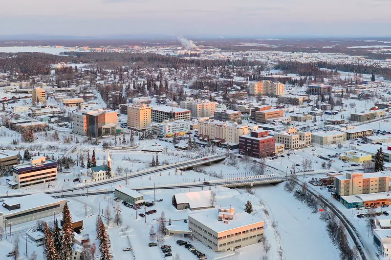
A compact centre on the Chena River, which is where the 1901 trading post stood.
The university district
On the western edge of town, where the University of Alaska Fairbanks campus sits on a ridge. The University of Alaska Museum of the North is on the campus, at 1962 Yukon Drive.
The Chena Hot Springs road
Northeast out of town along Chena Hot Springs Road toward Chena Hot Springs Resort. Explore Fairbanks lists the Chena River State Recreation Area, reached by this road, among its aurora viewing locations.
The pipeline corridor
North of the city, where the Trans-Alaska Pipeline runs above ground and can be seen from the road.
The Food Stop
Fairbanks is the last place with a full range of shops and restaurants before the Dalton, which makes it a resupply point as much as a meal stop. We were unable to confirm a specific Fairbanks restaurant for this guide, and this guide does not name a business without checking that business's own site. The practical point stands regardless: whatever you intend to eat north of here, buy it in Fairbanks, because the highway has no grocery stores at all.
4 breweries within 10 miles of Fairbanks, 2 of them brewpubs with a kitchen.
See all 4
- Latitude 65 Brewing Company150 Eagle Ave Unit B, Fairbanks
- Silver Gulch Brewing Co2195 Old Steese Highway, Fairbanks
- HooDoo Brewing Co1951 Fox Ave, Fairbanksproduction site*
- Midnite Mine Brewpub308 Wendell Ave, Fairbanksproduction site*
*Check before you go. This list says what the source records as open and where it is — nothing more. Opening hours, whether a kitchen is serving, and whether anywhere suits your family are not in this data and change without notice. A production site may have no public room at all. Please confirm with the venue.
Brewpub locations from Open Brewery DB (MIT)
The Home Teams
No MLB, NFL, NBA, NHL or MLS team plays in Fairbanks. The University of Alaska Fairbanks Nanooks (collegiate hockey, basketball, volleyball and rifle) and the Alaska Goldpanners, an amateur summer baseball club that prepares college athletes for professional baseball, are among the local teams. The Goldpanners' Midnight Sun Game is played around the summer solstice without artificial lights.
Day Trips
| Destination | Time | Distance | How we got it |
|---|---|---|---|
| The Arctic Circle via the Dalton | 4 hr 50 min | 194 mi | routed |
| North through Livengood and up the gravel to the Arctic Circle sign. A long day there and back, on a road that punishes unprepared vehicles. | |||
| Chena Hot Springs | 1 hr 25 min | 61 mi | routed |
| Northeast of the city, about 60 miles by the resort's own account: Chena Hot Springs Resort lists an outdoor hot springs lake (guests 18 and over), an indoor heated pool, indoor and outdoor hot tubs, aurora viewing, and an Aurora Ice Museum kept at 25°F year-round. | |||
| North Pole, Alaska | 20 min | 14 mi | routed |
| South of Fairbanks on the Richardson Highway, a town whose tourism listing gives its slogan as “Where the spirit of Christmas lives year-round.” Explore Fairbanks notes streetlights decorated in candy cane motifs along Santa Claus Lane. | |||
| Denali National Park | 2 hr 30 min | 122 mi | routed |
| South on the George Parks Highway (Alaska Highway 3) to the park's road entrance at mile 237, which the National Park Service places 120 miles south of Fairbanks. | |||
| The pipeline viewpoint and Fox | 2 hr 20 min | 118 mi | routed |
| North of the city on the Steese Highway, a pipeline viewing site sponsored by the Alyeska Pipeline Service Company at Mile 8.4, with information displays and parking. | |||
Routed figures are computed over map data at free-flowing speeds, between map points rather than street addresses, so a real drive runs longer.
Distances routed by OSRM and places geocoded by Nominatim, over map data © OpenStreetMap contributors (ODbL)
Annual Events Nearby
Within 60 miles of Fairbanks, nearest first.
What is on, and when
World Eskimo-Indian Olympicscultural festivalFairbanks
- Usually
- July, over several days
- Since
- 1961
Tanana Valley State Fair — some details below are unconfirmedfairFairbanks
- Usually
- Early August
- Held at
- Tanana Valley Fairgrounds
* We could not confirm: anything beyond the month it usually runs. Check their site before you go.
This is a list of what is near you, not a recommendation of any of it. Events are listed by the month they usually fall in, because that is what we hold — we do not publish dates, and a month is not a promise. Check the organiser before you plan around one. One entry is marked with an asterisk: we could not confirm part of what is listed, and the note under it says which part. Opening times, line-ups and ticketing change without notice, so check the venue’s or organiser’s own site — every name above links to it.
Practical Road Trip Info
The Dalton is not an ordinary road and should not be treated as one. Spare tyres, extra oil, no groceries, no medical facilities, heavy truck traffic, and snow possible in any month north of Coldfoot.
Buy everything in Fairbanks. This is the last full-service town before 414 miles of gravel.
Winter here is a different activity from summer. Under four hours of daylight in late December, against nearly twenty-two in June, and a recorded low of −66°F.
Check 511.alaska.gov. The BLM points drivers there for current conditions, and on this road that is a pre-departure step rather than a precaution.
The Local Debate
Family-Friendly
North Pole, Alaska
Streetlights decorated in candy cane motifs along Santa Claus Lane, in a town whose slogan is “Where the spirit of Christmas lives year-round.”
Chena Hot Springs
Chena Hot Springs Resort says guests must be 18 or over to use the outdoor hot springs and that guests under 18 may use the indoor pool and hot tubs; it also runs an Aurora Ice Museum that it lists as open every day of the year. The resort's own pages give the age limit for each tour.
The aurora
Visible on more than 200 nights a year on average, which makes a winter trip a genuine prospect rather than a gamble.
The pipeline up close
A pipeline viewing site at Mile 8.4 of the Steese Highway, sponsored by the Alyeska Pipeline Service Company, with information displays and parking. We were unable to confirm from an official source whether visitors can touch the pipe.
Plan Your Visit
The Dalton Highway
- Route
- 414 miles from Livengood, 84 miles north of Fairbanks, to Deadhorse and the Prudhoe Bay oilfields
- Surface
- Narrow, rough, steep and mostly gravel; dust, slick mud and sudden potholes
- Services
- No medical facilities or grocery stores; four BLM campgrounds open late May to early September; Arctic Interagency Visitor Center at Coldfoot
- Communications
- Cell service limited to GCI and AT&T, and only at Coldfoot and scattered locations
- Preparation
- Check tyres and fluids, carry extra motor oil and spare tyre(s), consider a CB radio on channel 19
- Conditions
- Snow and ice possible in any month north of Coldfoot; wildfires increasingly common; alerts at 511.alaska.gov
We checked seasonal opening, operating status, opening hours and fees on 2026-10-12. These change without notice — confirm with blm.gov, goldpanners.com, chenahotsprings.com and nps.gov the week you travel.
Sources — 29 claims, 28 checked against the source on 2026-10-12
| Claim | Source | Status |
|---|---|---|
| The Dalton Highway is 414 miles long, running from Livengood, 84 miles north of Fairbanks, to Deadhorse and the Prudhoe Bay oilfields; built in the 1970s to allow construction of the trans-Alaska oil pipeline; a “mostly gravel highway” through forested hills, the Brooks Range and the North Slope | Dalton Highway — Bureau of Land Management | Checked |
| “There are no medical facilities or grocery stores”; four developed BLM campgrounds open late May through early September, plus rest areas and interpretive panels; the Arctic Interagency Visitor Center is in Coldfoot; cell service limited to GCI and AT&T and only in Coldfoot and scattered locations | Dalton Highway — Bureau of Land Management | Checked monitored · 2026-10-12 |
| The road is “narrow, rough, steep, and mostly gravel” with “clouds of dust, slick mud, and sudden potholes”; it is “primarily an industrial corridor, with heavy truck traffic”; north of Coldfoot snow and ice are possible in any month; lightning-caused wildfires are “increasingly common”; advice to check tyres and fluids, carry extra motor oil and spare tyre(s), consider a CB radio on channel 19, and check 511.alaska.gov | Dalton Highway — Bureau of Land Management | Checked |
| The BLM page does not mention fuel availability or fuel spacing along the Dalton Highway | Dalton Highway — Bureau of Land Management | Checked |
| “The 2020 census put the population of the city proper at 32,515”; the Fairbanks North Star Borough had 95,655; elevation 446 feet | Fairbanks, Alaska — Wikipedia | Checked |
| E. T. Barnette founded a trading post in August 1901 and the city was incorporated in November 1903; “The settlement was named after Charles W. Fairbanks”, an Indiana senator who later became US vice president | Fairbanks, Alaska — Wikipedia | Checked |
| “The northern lights, which are visible on average more than 200 days per year in the vicinity of Fairbanks&rdquo | Fairbanks, Alaska — Wikipedia | Checked |
| “The highest recorded temperature in Fairbanks was 99 °F (37 °C) on July 28, 1919”; record low −66°F on 14 January 1934; “Fairbanks experiences 3 hours and 41 minutes of sunlight on December 21 and 22”, against about 21 hours 49 minutes at the summer solstice | Fairbanks, Alaska — Wikipedia | Checked |
| After oil was discovered at Prudhoe Bay in 1968 the city “became a supply point for the oil field, as well as for the Trans-Alaska Pipeline System”; the Elliott Highway connects Fairbanks to Livengood, the “southern terminus of the Dalton Highway&rdquo | Fairbanks, Alaska — Wikipedia | Checked |
| Services chart marks gas as available at Yukon Crossing (milepost 56), Coldfoot (milepost 175) and Deadhorse (milepost 414); in winter services of any kind are limited to those three places; mileage chart gives 239 miles from Coldfoot to Deadhorse; the bring list includes extra gasoline (2024 edition, checked 2026-10-14) | The Dalton Highway Visitor Guide (2024) — Bureau of Land Management | Checked monitored · 2026-10-14 |
| The wayside is at milepost 115 on the Dalton Highway; a sign notes the Arctic Circle; an observation deck with interpretive panels; parking for 20 vehicles; listed coordinates 66.555833, -150.810833 (checked 2026-10-14) | Arctic Circle Wayside — Bureau of Land Management | Checked monitored · 2026-10-14 |
| A named, verified Fairbanks restaurant for the food stop | No source accepted yet | Not confirmed |
| The museum is on the UAF campus at 1962 Yukon Drive, Fairbanks (checked 2026-10-14) | University of Alaska Museum of the North — University of Alaska Fairbanks | Checked |
| A Trans-Alaska Pipeline viewing site sponsored by the Alyeska Pipeline Service Company, with information displays and parking, is listed at Mile 8.4 of the Steese Highway (2021 edition of the guide, checked 2026-10-14) | Alaska's Historic Steese and Elliott Highways — Bureau of Land Management | Checked monitored · 2026-10-14 |
| Mileage chart: Fairbanks to Livengood 84 miles, to the Arctic Circle 199 miles, to Coldfoot 259 miles (checked 2026-10-14); official distances for Chena Hot Springs (about 60 miles), North Pole (15 miles) and Denali (120 miles) are in the rows above | The Dalton Highway Visitor Guide (2024) — mileage chart | Checked |
| Summer hours 12 p.m. to 9 p.m., late May through mid-September, including holidays; a partnership of the BLM, National Park Service and U.S. Fish and Wildlife Service at Coldfoot (milepost 175); for winter the BLM Coldfoot Contact Station keeps limited hours with park rangers on hand (checked 2026-10-14) | Arctic Interagency Visitor Center — Bureau of Land Management | Checked monitored · 2026-10-14 |
| The UAF campus is poised on a ridge on the western edge of town (checked 2026-10-14) | University of Alaska Fairbanks — Explore Fairbanks | Checked |
| Chena River State Recreation Area is listed among aurora viewing locations and is reached by Chena Hot Springs Road, which starts 4 miles from Fairbanks and runs 58 miles to Chena Hot Springs Resort (checked 2026-10-14) | Aurora viewing locations — Explore Fairbanks | Checked |
| The resort is approximately 60 miles northeast of Fairbanks, reached year-round on a state-maintained road via Chena Hot Springs Road (checked 2026-10-14) | Chena Hot Springs Resort — history and location | Checked |
| Outdoor hot springs lake is for guests 18 and over; guests under 18 may use the indoor pool and hot tubs; the resort lists itself as open 365 days a year (checked 2026-10-14) | Chena Hot Springs Resort — hot springs | Checked monitored · 2026-10-14 |
| The museum is kept at 25 F year-round and is listed as open every day, 365 days a year (checked 2026-10-14) | Chena Hot Springs Resort — Aurora Ice Museum | Checked monitored · 2026-10-14 |
| Streetlights decorated in candy cane motifs along Santa Claus Lane; the town describes itself with the slogan 'the spirit of Christmas lives year-round' (checked 2026-10-14) | North Pole — Explore Fairbanks | Checked |
| Slogan 'Where the spirit of Christmas lives year-round'; listed as 15 miles from Fairbanks (checked 2026-10-14) | City of North Pole Tourism — Explore Fairbanks listing | Checked |
| North Pole is south of Fairbanks on the Richardson Highway (checked 2026-10-14) | North Pole, AK — Travel Alaska | Checked |
| The park's road entrance is at mile 237 of Alaska Highway 3 (the George Parks Highway); the NPS places the park 120 miles south of Fairbanks (checked 2026-10-14) | Directions & Transportation — Denali National Park & Preserve | Checked |
| The game is played every year around the summer solstice (June 21) in Fairbanks and is played without artificial lights; dates vary slightly each year (checked 2026-10-14) | Midnight Sun Game — Alaska Goldpanners | Checked monitored · 2026-10-14 |
| The club operates in a manner similar to a minor league team, preparing college athletes for professional baseball (checked 2026-10-14) | Team history — Alaska Goldpanners | Checked |
| The University of Alaska Fairbanks Nanooks play collegiate hockey, basketball, volleyball and rifle; the Alaska Goldpanners start their solstice game at 10:30 p.m. without artificial lighting (checked 2026-10-14) | Team and recreational sports — Explore Fairbanks | Checked |
| Designated a National Scenic Byway by the U.S. Secretary of Transportation; 230 miles in AK; FHWA suggests: Four hours (checked 2026-10-29) | Federal Highway Administration: The George Parks Highway Scenic Byway | Checked |
Road Trippin’ with the Harts
The Highway Heads books turn the miles between stops into a game the whole car can play.
See the booksLive Conditions
Wildlife Spotted Nearby
Nearest Airports
Straight-line distance from Fairbanks, not drive time.
- Fairbanks International (FAI) — 4 miles
- Nenana Municipal (ENN) — 45 miles
- Minto Al Wright (MNT) — 53 miles
Explore the Full Road Trip
Return to the Highway Heads map and discover the next family-ready stop.
Explore the Map