
Fast Facts
- Population
- ~583 year-round (2020 census)
- Typical visiting season
- June–early Oct (ferry season)
- One Unusual Stat
- Cars banned since 1898
- How to get there
- Ferry only, from St. Ignace or Mackinaw City
What to Know Before You Arrive
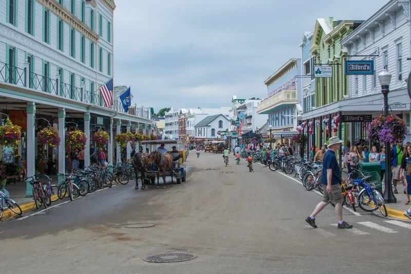
There is no road onto Mackinac Island, no bridge, and no cars — motorized vehicles have been prohibited within the City of Mackinac Island since 1898 and island-wide since 1901. Everyone gets around the same way: on foot, by bicycle, on horseback, or by horse-drawn carriage. This isn't a novelty add-on for tourists; it's simply how the island has worked for well over a century, which means your own trip planning has to work the same way — no rental car, no drive time, just ferry time.
Getting there means a ferry from one of two mainland towns, St. Ignace or Mackinaw City, both near the Mackinac Bridge over the Straits of Mackinac. Ferry service runs seasonally during the tourist months; companies like Shepler's have operated the crossing since 1945, when Captain William H. Shepler returned from World War II and started the business. Check current schedules and crossing times before you go — this is a boat trip, not a drive, and it needs to be timed differently.
The island's two headline landmarks are Fort Mackinac and the Grand Hotel. The British built the limestone fort in 1780–81 under lieutenant governor Patrick Sinclair to control the strategic straits and the Great Lakes fur trade; it changed hands during the Revolutionary War and again during the War of 1812, closed as an active fort in 1895, and is now a museum inside Mackinac Island State Park. The Grand Hotel, a Victorian-style resort, opened in 1887 and has anchored the island's tourism identity ever since.
The Road Trip Stop
Fort Mackinac is the anchor historic stop — built by the British in 1780–81 on the island's limestone bluffs to control the Straits of Mackinac and the Great Lakes fur trade, and now a museum run by the Mackinac Island State Park Commission, which has governed the fort and surrounding historic sites since 1895. It's the rare fort you can walk to directly from the ferry dock without a car anywhere in the plan.
Budget the time
- Check the ferry schedule before anything else. The Mackinac Island Tourism Bureau names two passenger ferry companies, Shepler's Mackinac Island Ferry and Arnold Transit Company, both running from Mackinaw City and St. Ignace from late April through the end of October, and says schedules vary throughout the season.
- 90 minutes to two hours covers Fort Mackinac, including the overlook views down onto the harbor and Main Street.
- Rent a bike on the island if you want to circle it — the Mackinac Island Tourism Bureau calls biking, running or walking the 8.2 miles around the island on State Highway M-185, a car-free road, a popular activity for visitors, and says many bicycle shops on the island rent bikes. Bikes can also come over on the ferry: Shepler's and Arnold Transit Company each require a separate bike ticket or pass.
- Plan your return ferry time in advance; the Mackinac Island Tourism Bureau gives the last ferry off the island as 8:00 pm in the slower season and as late as 10:00 pm during peak season, and Arnold Transit Company's 2026 schedule lists a last departure from the island at 5:00 PM for Oct. 26–31. Check the final departure for your date with the operator.
Neighborhoods
Downtown / Main Street
The harbor-front commercial strip where the ferries dock — fudge shops, hotels and restaurants, all within walking distance of the boat.
Fort Mackinac & the bluff
The high ground above downtown where the fort sits, with the best overlook views of the harbor and straits.
The Grand Hotel grounds
The west side of the island, where the 1887 Grand Hotel sits above its own private grounds and gardens.
The island interior & perimeter road
Away from downtown: Mackinac Island State Park land, which Mackinac State Historic Parks says holds 70.5 miles of signed and interpreted roads and trails, and State Highway M-185, the car-free road that circles the island's outer rim, which the Tourism Bureau measures at 8.2 miles and describes as a popular way to bike, run or walk.
The Food Stop
Fudge is the island's signature food business, and it has been since the Murdick family opened what's recognized as the island's first real candy store. Several fudge shops now line Main Street; the friendly rivalry between them is part of the walk from the ferry dock.
Beyond fudge, Main Street's restaurants run on the same seasonal tourist rhythm as everything else on the island — busiest at midday when ferry crowds are highest. Away from the main strip, Mackinac State Historic Parks lists a Tea Room in Fort Mackinac's historic Officers' Stone Quarters, serving snacks and beverages all day and lunch from 11:00 a.m. to 3:00 p.m.; valid fort admission is required to use it.
Been here a while
Places that have been serving a long time. All were still trading when we last checked. Each name links to its source.
- Murdick's FudgeSays it opened as Murdick's Candy Kitchen in 1887, the island's first candy shop (per the business)
Day Trips
| Destination | Time | Distance | How we got it |
|---|---|---|---|
| Mackinaw City (mainland) | — | — | |
| The southern ferry departure point, with Colonial Michilimackinac and the Mackinac Bridge itself as mainland attractions before or after the island. Ferry crossing, not a drive. | |||
| St. Ignace (mainland) | — | — | |
| The northern ferry departure point on the Upper Peninsula side, with its own small downtown and the Museum of Ojibwa Culture. Ferry crossing, not a drive. | |||
| Mackinac Bridge | n/a — view only unless driving the mainland | Visible from the island | estimated |
| The Mackinac Bridge, a suspension bridge the Mackinac Bridge Authority lists at 5 miles in total length, connects Michigan's upper and lower peninsulas at the Straits of Mackinac, with Mackinaw City at its south end and St. Ignace at its north end. The Tourism Bureau says it comes into view from British Landing when circling the island counter-clockwise on M-185, and Shepler's schedule includes “Mighty Mac” ferry departures that travel under it. | |||
| Sault Ste. Marie & the Soo Locks | 2 hr 55 min | 90 mi | routed |
| About 47 miles north-east of St. Ignace in a straight line, Sault Ste. Marie is home to the Soo Locks, which the U.S. Army Corps of Engineers operates on the St. Marys River between Lake Superior and Lake Huron so that ships can travel between Lake Superior and the lower Great Lakes. | |||
Routed figures are computed over map data at free-flowing speeds, between map points rather than street addresses, so a real drive runs longer. Rows marked estimated are this guide’s own figure and have not been routed.
Distances routed by OSRM and places geocoded by Nominatim, over map data © OpenStreetMap contributors (ODbL)
Wildlife Parks Nearby
Within 60 miles of Mackinac Island, nearest first.
Oswald's Bear RanchNewberry
- Hours
- Daily 9:30am-5pm (4pm after Labor Day); gate closes 30 min early
- Season
- seasonal (Memorial Day weekend-first Sunday of Oct)
- Admission
- Adult from $30 ($15 single visitor) · Child included in per-vehicle fee
This is a list of what is near you, not a recommendation of any of it. None of these carry an accreditation we were able to confirm, which is not the same as none being accredited — we check against one register, and plenty of good municipal, state and university places are in no register at all. Opening times, prices and seasons change without notice, so check the operator’s own site — every name above links to it.
Historic Sites Nearby
1 near Mackinac Island, each checked against the operator or agency that runs it.
Main Street, downtown Mackinac IslandPublic spaceMackinac Island
- Hours
- Public street; no hours on any official page. (The state's downtown museum sites have their own seasonal hours.)
- Admission
- Street itself has no stated fee. The state's Historic Downtown Mackinac museum ticket is $11 adult / $8 child (5-12) for 2027 per the same page.
- Season
- Closed for the 2026 season. Open for the 2027 season May 7! source
Main Street runs through Mackinac Island's downtown business district; the state's Mackinac Art Museum, beside Marquette Park just below Fort Mackinac, has its entrance off it. The state-run downtown museum sites are closed for the 2026 season and reopen in spring 2027.
- No city page for the street; official URL is the state parks' downtown museums page
- Island's no-cars status not confirmed from a primary page in this pass
- State museum sites closed for the 2026 season (art museum reopens May 7, 2027; others June 5, 2027)
Run by Street: City of Mackinac Island (not confirmed from a city page). Downtown museum sites: Mackinac State Historic Parks
This is a list of what is near you, not a recommendation of any of it. Opening times and prices here are quoted from each operator’s own page on the date we read it, and both change without notice. Where this list says an operator does not publish their hours or their price, that is what we found on their page — 1 of these publish no hours and 1 state no price. A blank is not “free” and not “always open”, so ring ahead where it matters. Every name above links to that page.
Practical Road Trip Info
A full day is the minimum — ferry over, Fort Mackinac, Main Street, and the return ferry. Two days lets you add a full bike loop of the island and the Grand Hotel grounds unhurried.
Ferry season runs from late April through October; Shepler's lists its 2026 navigational season as April 21 – October 31, and Arnold Transit Company lists fast-ferry service on the same dates. Confirm current operating months and schedules with either operator before you plan a trip.
Ferry fares differ by company. For 2026, Shepler's lists adult round-trip tickets at $39* and ages 5–12 at $27*, plus a $2* booking fee per ferry ticket; Arnold Transit Company lists fast-ferry adult round trips at $37* and ages 5–12 at $25*, with all tickets subject to a booking fee. Check each operator's site for current round-trip pricing before you go.
No cars means no rental-car logistics — but it also means everything you carry, you carry by hand, bike basket, or carriage. Pack accordingly.
*Fees subject to change, please check sheplersferry.com for updated information.
*Fees subject to change, please check arnoldtransitcompany.com for updated information.
The Local Debate
Family-Friendly
Fort Mackinac
Mackinac State Historic Parks lists costumed-interpreter demonstrations and tours throughout the day, cannon firing demonstrations, and a Kids' Quarters exhibit with hands-on displays and interactive games. The fort sits on the bluff overlooking the City of Mackinac Island and Haldimand Bay.
Bike rental and a short perimeter ride
A car-free island is genuinely one of the easiest places in the country to let kids ride without traffic worry — scale the distance to the youngest rider.
Fudge shop crawl on Main Street
A short walk from the ferry dock with a built-in reward at the end; kids old enough to walk the strip will remember the fudge more than the fort.
Horse-drawn carriage tour
Mackinac Island Carriage Tours runs a narrated horse-drawn tour of the island that its page puts at about 1 hour and 45 minutes, with stops at Surrey Hills Museum, Wings of Mackinac, Arch Rock (a viewing of about five minutes) and the Fort Mackinac Avenue of Flags. The company says there are no set departure times and that reservations are not accepted for the regular public tour; children age 4 and under ride free if held on a lap.
Plan Your Visit
Fort Mackinac
- Address
- 7127 Huron Rd, Mackinac Island, MI 49757
- Hours
- Seasonal; check ahead
- Price
- See Mackinac State Historic Parks site for current admission
We checked seasonal opening, operating status, opening hours and fees on 2026-09-22. These change without notice — confirm with en.wikipedia.org, mackinacisland.org, sheplersferry.com, arnoldtransitcompany.com, mackinacparks.com, grandhotel.com and mict.com the week you travel.
Sources — 33 claims, 29 checked against the source on 2026-09-22
| Claim | Source | Status |
|---|---|---|
| Motorized vehicles prohibited within the City of Mackinac Island since 1898, and on the island since 1901; ferry service available in summer tourist season from Shepler's Ferry and Mackinac Island Ferry Company (formerly Star Line) from St. Ignace and Mackinaw City; year-round population 583 (2020 census); travel on the island is by foot, bicycle, horse or horse-drawn carriage; the Murdick family created the first real candy store (fudge) | Mackinac Island — Wikipedia | Checked monitored · 2026-09-22 |
| Grand Hotel is a Victorian-style structure that opened in 1887 | Mackinac Island — Wikipedia | Checked |
| Fort Mackinac built 1780/1781 by British lieutenant governor Patrick Sinclair on 150-ft limestone bluffs; built during the American Revolutionary War to control the Straits of Mackinac and Great Lakes fur trade; British held it until Jay Treaty ratified 1796; captured by combined British/Native American force in July 1812, recaptured by Americans 1815 after Treaty of Ghent; closed as an active fort 1895; Mackinac Island State Park Commission has governed it since 1895; now a museum in Mackinac Island State Park | Fort Mackinac — Wikipedia | Checked |
| Shepler's Mackinac Island Ferry operates from docks in Mackinaw City and St. Ignace; founded by Captain William H. Shepler in 1945 after WWII service; built his own 24-passenger boat in 1950; purchased by Hoffman Family of Companies in early 2022 | Shepler's Ferry — Wikipedia | Checked |
| Arch Rock is a natural limestone arch formed during the Nipissing post-glacial period, standing on the Lake Huron shoreline 146 feet above the water, on the southeast coast of Mackinac Island (checked 2026-10-15) | Arch Rock (Mackinac Island) — Wikipedia | Checked |
| Mackinac State Historic Parks says the state park encompasses more than 80% of Mackinac Island, most of it in its natural condition, with Fort Mackinac, Arch Rock and Sugarloaf Rock among the landmarks within it, and 70.5 miles of signed and interpreted roads and trails (checked 2026-10-15) | Mackinac Island State Park — Mackinac State Historic Parks | Checked |
| The Mackinac Bridge Authority lists the suspension bridge's total length at 5 miles (26,372 feet) (checked 2026-10-15) | Mackinac Bridge Authority — Facts & Figures | Checked |
| Colonial Michilimackinac is a reconstructed 18th-century fort and fur-trading village in Mackinaw City | Colonial Michilimackinac — Wikipedia | Not confirmed |
| Museum of Ojibwa Culture is located in St. Ignace, Michigan | Museum of Ojibwa Culture — Wikipedia | Not confirmed |
| The Soo Locks in Sault Ste. Marie, Michigan, operated by the U.S. Army Corps of Engineers, sit on the St. Marys River between Lake Superior and Lake Huron and let ships travel between Lake Superior and the lower Great Lakes (checked 2026-10-15) | Soo Locks — Wikipedia | Checked |
| Fort Mackinac address, hours, and current admission | Mackinac State Historic Parks — official site | Not confirmed |
| Bike rental locations and prices | No source accepted yet | Not confirmed |
| Names Shepler's Mackinac Island Ferry and Arnold Transit Company as the passenger ferry companies, each running from Mackinaw City and St. Ignace from late April through the end of October, and says schedules vary throughout the season (checked 2026-10-15) | Mackinac Island Tourism Bureau — Getting Here | Checked monitored · 2026-10-15 |
| Describes State Highway M-185 as the car-free road around the island's outer rim, 8.2 miles long, calls biking, running or walking it a popular activity for visitors, and says riders can bring a bicycle or rent one from the many bicycle shops on the island (checked 2026-10-15) | Mackinac Island Tourism Bureau — the 8.2-mile trek around the island | Checked monitored · 2026-10-15 |
| Bikes, burleys and bike trailers each require their own round-trip ferry ticket (checked 2026-10-15) | Shepler's Ferry — Travel FAQs | Checked monitored · 2026-10-15 |
| Bikes can ride the ferry with a bike pass bought at the ticket booth (checked 2026-10-15) | Arnold Transit Company — Travel FAQs | Checked monitored · 2026-10-15 |
| Gives the last ferry off the island as 8:00 pm in the slower season and as late as 10:00 pm during peak season, and advises double-checking the schedule, port city and times (checked 2026-10-15) | Mackinac Island Tourism Bureau — Getting Here (last ferry) | Checked monitored · 2026-10-15 |
| The Oct. 26-31, 2026 schedule lists a last departure from Mackinac Island at 5:00 PM; schedules are subject to change without notice (checked 2026-10-15) | Arnold Transit Company — Summer Ferry Schedule | Checked monitored · 2026-10-15 |
| Lists a $14.00 admission fee for adults and $7.00 for ages 6-12 (ages 5 and under free) to enter the hotel and explore the grounds (checked 2026-10-15) | Grand Hotel — FAQs | Checked monitored · 2026-10-15 |
| Admission tickets are redeemed at the Admissions Desk at the east end entrance, and ticket-holders are encouraged to explore the grounds and relax on the Front Porch (checked 2026-10-15) | Grand Hotel — Purchase Admissions | Checked monitored · 2026-10-15 |
| After 6:30 PM the hotel requires elevated evening attire in parlor-level areas, including the Front Porch (checked 2026-10-15) | Grand Hotel — Hotel Policies and Information | Checked monitored · 2026-10-15 |
| Describes a pull-off with bicycle racks beside M-185 and 207 steps from the road up to Arch Rock (checked 2026-10-15) | Mackinac Island Tourism Bureau — the 8.2-mile trek (Arch Rock stop) | Checked |
| The Tea Room in Fort Mackinac's Officers' Stone Quarters serves snacks and beverages all day and lunch from 11:00 a.m. to 3:00 p.m.; valid fort admission is required (checked 2026-10-15) | Mackinac State Historic Parks — Tea Room Restaurant | Checked monitored · 2026-10-15 |
| The bridge connects Michigan's upper and lower peninsulas at the Straits of Mackinac, with Mackinaw City at the south end and St. Ignace at the north end (checked 2026-10-15) | Mackinac Bridge Authority — Location | Checked |
| Says the Mackinac Bridge comes into view at British Landing when circling the island counter-clockwise on M-185 (checked 2026-10-15) | Mackinac Island Tourism Bureau — the 8.2-mile trek (bridge view) | Checked |
| Mighty Mac departures travel under the Mackinac Bridge for a brief narrated tour (checked 2026-10-15) | Shepler's Ferry — Travel FAQs (Mighty Mac departures) | Checked monitored · 2026-10-15 |
| Tickets are valid for any departure from Mackinaw City or St. Ignace during the navigational season, April 21 - October 31, 2026 (checked 2026-10-15) | Shepler's Ferry — Travel FAQs (season) | Checked monitored · 2026-10-15 |
| Fast ferry service from Mackinaw City and the St. Ignace Main Dock runs April 21 - October 31, 2026 (checked 2026-10-15) | Arnold Transit Company — Summer Ferry Schedule (season) | Checked monitored · 2026-10-15 |
| Lists 2026 round-trip tickets at $39 for adults and $27 for ages 5-12, with a $2 booking fee per ferry ticket (checked 2026-10-15) | Shepler's Ferry — Ticket Options | Checked monitored · 2026-10-15 |
| Lists 2026 fast-ferry round trips at $37 for adults and $25 for ages 5-12; all tickets are subject to a booking fee (checked 2026-10-15) | Arnold Transit Company — Summer Ferry Rates | Checked monitored · 2026-10-15 |
| Lists costumed-interpreter demonstrations and tours, cannon firing demonstrations and a hands-on exhibit with interactive games; the fort stands on the bluff overlooking the City of Mackinac Island and Haldimand Bay (checked 2026-10-15) | Mackinac State Historic Parks — Fort Mackinac | Checked monitored · 2026-10-15 |
| Narrated horse-drawn carriage tour of about 1 hour and 45 minutes with stops at Surrey Hills Museum, Wings of Mackinac, Arch Rock and the Fort Mackinac Avenue of Flags; no set departure times; reservations not accepted for the regular public tour; ages 4 and under ride free on a lap (checked 2026-10-15) | Mackinac Island Carriage Tours — Carriage Tours | Checked monitored · 2026-10-15 |
| Motorized vehicles prohibited within the City of Mackinac Island since 1898, and on the island since 1901; ferry service available in summer tourist season from St. Ignace and Mackinaw City; year-round population 583 (2020 census); travel on the island is by foot, bicycle, horse or horse-drawn carriage; the Murdick family created the first real candy store (fudge) | Mackinac Island — Wikipedia | Checked monitored · 2026-10-15 |
Road Trippin’ with the Harts
The Highway Heads books turn the miles between stops into a game the whole car can play.
See the booksLive Conditions
Wildlife Spotted Nearby
Nearest Airports
Straight-line distance from Mackinac Island, not drive time.
- Pellston Regional Airport of Emmet County (PLN) — 21 miles
- Chippewa County International (CIU) — 28 miles
- Welke — 44 miles
Explore the Full Road Trip
Return to the Highway Heads map and discover the next family-ready stop.
Explore the Map