
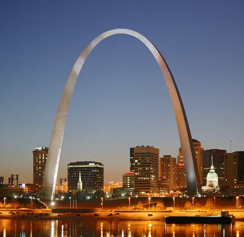
Gateway Arch National Park, a National Park Service site on the Mississippi River in downtown St. Louis, consists of the Gateway Arch, the free history museum beneath it, 90 acres of grounds and the Old Courthouse. The tram ride to the top rises 630 feet and the park asks visitors to allow 45 to 60 minutes; it runs on timed tickets sold through the park partner, with adult tickets from $15* to $19* depending on the day, advance purchase recommended because busy days sell out, and the NPS notes that the tram is not ADA accessible. The museum and the Old Courthouse are free and need no ticket; the visitor center is open 9 a.m. to 6 p.m. daily (until 8 p.m. on Fridays and Saturdays in summer), the Old Courthouse 9 a.m. to 5 p.m., and the park is closed on Thanksgiving, Christmas and New Year's Day. Every visitor passes an airport-style security checkpoint, and the park runs no parking of its own: it lists a preferred rate of $11* for five hours at the Stadium East garage, pre-purchased on Cardinals home-game dates.
Great River Road runs within 1.1 miles: the Federal Highway Administration designates it an All-American Road, 2,069 miles through AR, IL, IA, KY, LA, MN, MS, MO, TN, WI. Historic Route 66 runs through here: the Federal Highway Administration designates it an All-American Road, 1,408.6 miles through AZ, IL, NM, OK, CA, MO.
*Fees subject to change, please check nps.gov for updated information.
Been here a while
Long-standing places to eat near Gateway Arch, in the town named beside each rather than at the stop itself. All were still trading when we last checked. Names link to their sources.
- 1918Gioia's DeliSt. Louis (The Hill), MOHill neighborhood deli known for its boiled "hot salami"; James Beard America's Classic 2017
Lakes nearby
1 lake we have checked near Gateway Arch. These are the ones from our research that we could check against an official page — not every lake there is.
Carlyle Lake
- Fishingyes - fishing listed
- BoatingBoat ramps with courtesy docks at major areas; top inland sailing lake
- Rentals & marinaMarinas incl. Boulder, Trade Winds, West Access, Carlyle Sailing Assn
- Swimmingyes - McNair, Dam West, Keyesport, Coles Creek beaches
- CampingCorps campgrounds incl. Coles Creek (148 sites), Dam West (113), Boulder (82)
- Entry$5 beach day-use; $5 per boat launch or $40 annual pass
- SeasonDam West campground early April to Nov 1; East Spillway open all year
Run by US Army Corps of Engineers; Eldon Hazlet State Park (IDNR)
*Check before you go. Every lake here links to the official page we checked it against. Each states a price we read off that page on the date we checked. Fees, seasons, water levels, algal advisories and ramp closures change without notice and belong to the agency that runs the water. A blank is something we did not confirm, not something the lake lacks. Never assume a lifeguard. Whether a beach is staffed turns on the season, the day, and which agency runs that particular beach — two beaches on one lake can differ. If that matters to your family, confirm it with the agency before you set out.
Nearest Airports
Straight-line distance from Gateway Arch, not drive time.
- St. Louis Lambert International (STL) — 13 miles
- Scott AFB/Midamerica (BLV) — 20 miles
- St Louis Regional (ALN) — 20 miles
Live Conditions
Wildlife Spotted Nearby
We checked fees, reservations, opening hours, closures and operating status on 2026-10-14. These change without notice — confirm with nps.gov and gatewayarch.com the week you travel.
Sources — 11 claims, 11 checked against the source
| Claim | Source | Status |
|---|---|---|
| The park consists of the Gateway Arch, the free history museum beneath it, 90 acres of landscape and the Old Courthouse; tram tickets are sold through the park partner, Bistate Development; every visitor passes a security checkpoint (checked 2026-10-14) | National Park Service, Gateway Arch National Park: Basic Information | Checked |
| The park is in the heart of downtown St. Louis on the Mississippi River (checked 2026-10-14) | National Park Service, Gateway Arch National Park: Directions | Checked |
| Tram Ride to the Top adult tickets run from $15 to $19 depending on the day; the ride rises 630 feet and takes 45 to 60 minutes; the museum and the Old Courthouse are free and need no ticket (checked 2026-10-14) | National Park Service, Gateway Arch National Park: Fees & Passes | Checked monitored · 2026-10-14 |
| The tram ride uses a timed entry system; tickets bought in advance are recommended because busy days sell out; the tram is not ADA accessible (checked 2026-10-14) | National Park Service, Gateway Arch National Park: Fees & Passes (reservations) | Checked monitored · 2026-10-14 |
| Tram Ride to the Top: adult (16+) $15 - $19, price varying with the date of the visit (checked 2026-10-14) | The Gateway Arch (park partner ticketing): Buy Tickets | Checked monitored · 2026-10-14 |
| Visitor center and museum open 9:00 a.m.-6:00 p.m. daily, until 8 p.m. on Fridays and Saturdays Memorial Day to Labor Day; Old Courthouse 9:00 a.m.-5:00 p.m. daily (checked 2026-10-14) | National Park Service, Gateway Arch National Park: Operating Hours & Seasons | Checked monitored · 2026-10-14 |
| The park is closed on Thanksgiving, Christmas and New Year's Day (checked 2026-10-14) | National Park Service, Gateway Arch National Park: Operating Hours & Seasons (closures) | Checked monitored · 2026-10-14 |
| All visitors to the visitor center pass through an airport-style security checkpoint (checked 2026-10-14) | National Park Service, Gateway Arch National Park: Operating Hours & Seasons (security) | Checked monitored · 2026-10-14 |
| The park operates no parking facilities; its preferred parking program at the Stadium East garage is $11 for 5 hours, and on Cardinals home-game dates the discounted parking must be purchased by 11:59 p.m. the day before (checked 2026-10-14) | National Park Service, Gateway Arch National Park: Parking | Checked monitored · 2026-10-14 |
| Designated an All-American Road by the U.S. Secretary of Transportation; 2,069 miles in AR, IL, IA, KY, LA, MN, MS, MO, TN, WI; FHWA suggests: Allow six days to drive or ten days to enjoy the entire byway. Distance from this stop to the route measured against the published byway centreline on the U.S. Department of Transportation map service (geo.dot.gov), which carries no stated licence and predates the 2021 designations; the measurement is ours, the line is theirs and is not reproduced here. 1.1 miles (checked 2026-10-29) | Federal Highway Administration: Great River Road | Checked |
| Designated an All-American Road by the U.S. Secretary of Transportation; 1,408.6 miles in AZ, IL, NM, OK, CA, MO; FHWA suggests: You can drive the entire byway in four or five days, but to enjoy it, plan for several days per state. Distance from this stop to the route measured against the published byway centreline on the U.S. Department of Transportation map service (geo.dot.gov), which carries no stated licence and predates the 2021 designations; the measurement is ours, the line is theirs and is not reproduced here. 0.7 miles (checked 2026-10-29) | Federal Highway Administration: Historic Route 66 | Checked |