
Fast Facts
- Population
- 5,366 (2020 census)
- Elevation
- 4,025 ft, on the Colorado Plateau
- Best Season
- April–May and mid-September–October; summer often exceeds 100°F
- Nearest Interstate
- I-70, about 30 miles north — US 191 runs into town
- National Scenic Byway
- Dinosaur Diamond Prehistoric Highway, 480 miles
What to Know Before You Arrive
Nobody agrees where the name came from. Residents named the town in 1880, and one account links it to the biblical region east of the Jordan — possibly through postmaster William Andrew Peirce, who saw both places as “the far country.” Another traces it to the Paiute word moapa, meaning mosquito. A desert town named either for exile or for an insect is a reasonable introduction to the place.
Moab's economy started in agriculture and moved to mining. In the 1950s the geologist Charles Steen found a rich ore deposit south of the city and the town became known as the Uranium Capital of the World, growing by nearly 500 per cent. When the Cold War wound down the boom ended and the population fell sharply. What replaced it was the landscape: the national parks and, from the 1980s onward, mountain biking, with Moab as a base for riders using the trail network including the Slickrock Trail.
The practical fact that governs a visit is proximity. The entrance to Arches National Park is four miles north of Moab on US 191. That is close enough that the park's queues and the town's traffic are the same problem, and close enough that a bad decision about arrival time costs you the morning rather than the day.
The Road Trip Stop
Arches National Park is the anchor, four miles north on US 191. The standard entrance pass is $30* for a private vehicle, which “admits one private, non-commercial vehicle (15 passenger capacity or less) and all its occupants”; it is $25* for a motorcycle and $15* per person arriving on foot or by bicycle, with youth aged 15 and under admitted free.
Check the entry system before you rely on driving up
- Arches is not requiring timed-entry reservations in 2026. A Park Service news release dated 18 February 2026 states that the park “will not require advanced timed-entry reservations this year” and that visitors may enter at any time during operating hours; a valid entrance pass remains required. Arches operated a timed-entry system in recent seasons, the release is headed “Lifts Entry Reservation Requirement for 2026”, and reservations continue to be required for Devils Garden Campground and for self-guided and ranger-led Fiery Furnace hikes. The park's hours page says Arches “is normally open year-round, 24 hours a day” and is “very busy between March and October”, and recommends entering before 8 a.m. or after 3 p.m. to avoid traffic. The release adds that entrance lines and limited parking at popular destinations are possible at peak times and encourages visitors to check conditions before departing; the park's telephone number is 435-719-2299.
- The entrance station takes card only. Purchases at Arches are credit or debit, not cash.
- If you are doing more than one park, the local annual pass is the arithmetic to do. The $55* annual park pass covers a private vehicle at Arches, Canyonlands, Natural Bridges and Hovenweep, and is available to US citizens and residents. Two parks and it has paid for itself.
- There are fee-free days. In 2026 they fall on 16 February, 25 May, 14 June, 3–5 July, 25 August, 17 September, 27 October and 11 November. Those are also the busiest days of their respective months, and timed-entry or reservation fees may still apply.
*Fees subject to change, please check nps.gov for updated information.
From the Park Service
Arches National Park
- Entrance fee
- $30 private vehicle · $25 motorcycle (7-day) · $15 per person
- Park hours
- Open around the clock, every day. Arches National Park is generally open 24 hours a day, year-round.
- Reservations
- Reserve Fiery Furnace permits and ranger-led hike tickets online at www.recreation.gov or by calling 877-444-6777 (in North America) or +1 518-885-3639 (international).
- Visitor centre
- Arches Visitor Center. Open 7:30AM - 6:00PM daily.
- Campgrounds
- 1 in the park, about 51 sites in total. Fees from $25 to $250.
- Parking
- 3 mapped car parks and trailhead pull-offs
- Passport stamp
- Arches Visitor Center
- Webcams
- 2 live views on the park’s own site
National Park Service Data API, pulled 2026-10-12
Canyonlands National Park
- Entrance fee
- $30 private vehicle · $25 motorcycle (7-day) · $15 per person
- Park hours
- Open around the clock, every day. Canyonlands National Park is generally open 24 hours a day, year-round.
- Reservations
- You must have a permit for all private river trips. You may reserve overnight permits up to four months before the following seasons and reservations close two days prior to a launch date. Day use permits are available year round.
- Visitor centres
- Island in the Sky Visitor Center · The Needles Visitor Center · Hans Flat Ranger Station and 1 more. Open 8:00AM - 5:00PM daily.
- Campgrounds
- 3 in the park, about 41 sites in total. Fees from $15 to $225.
- Passport stamp
- Canyonlands Backcountry Office · Hans Flat Ranger Station · Island in the Sky Visitor Center and 1 more
National Park Service Data API, pulled 2026-10-12
Natural Bridges National Monument
- Entrance fee
- $20 private vehicle (7-day) · $15 motorcycle (7-day) · $10 per person (7-day)
- Park hours
- Open around the clock, every day. Natural Bridges National Monument is generally open 24 hours a day, year-round.
- Visitor centre
- Natural Bridges Visitor Center. Open 9:00AM - 5:00PM daily.
- Campgrounds
- 1 in the park, about 13 sites in total. Fees from $8 to $16.
- Passport stamp
- Natural Bridges Visitor Center
National Park Service Data API, pulled 2026-10-12
Neighborhoods
Main Street (US 191)
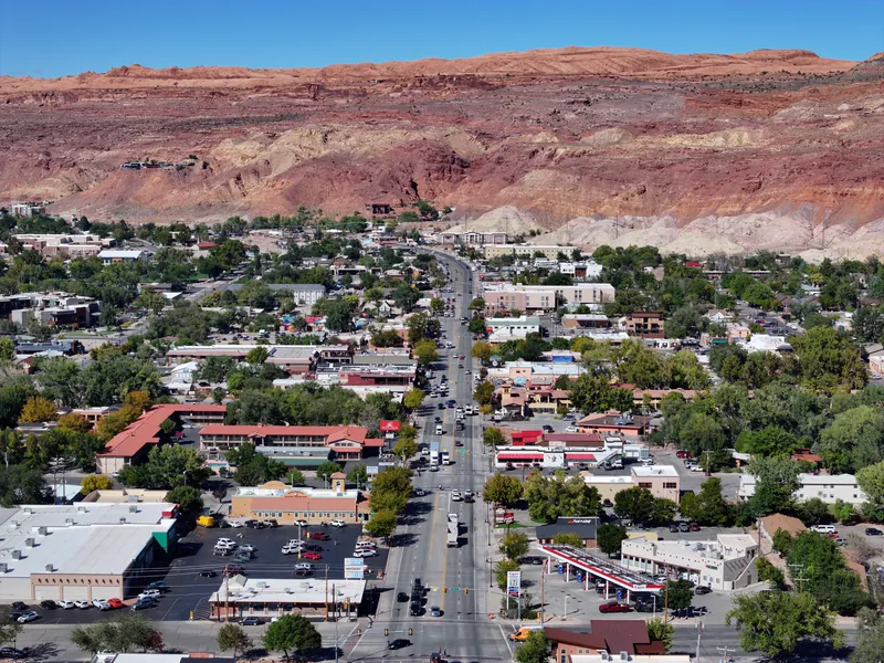
The highway through town is US 191, which a Utah Department of Transportation environmental assessment describes as the primary entrance to Moab from the north and the south and refers to as Moab Main Street. It is also the route to the park entrance, which is 4 miles north of Moab on US 191.
Millcreek Drive
East of the centre, heading toward the Slickrock Trail.
The Colorado River corridor
North of town along UT-128, which the Moab Office of Tourism describes as a route along the Colorado River gorge beginning at the Colorado River bridge at the north end of Moab and running within a narrow section of the gorge, with views of the surrounding red sandstone cliffs.
Spanish Valley
South of town, Spanish Valley is a flat in Grand and San Juan counties, lying south-southeast of the Moab valley, with farmland and housing; the La Sal Mountains rise above and southeast of Moab.
The Food Stop
Milt's Stop & Eat at 356 Millcreek Drive first opened in September 1954, under Milt Galbraith, which makes it older than the mountain-bike economy and older than most of the motels on the highway. Its own description of itself is unchanged in seventy years: “Milt's is still known for its delicious burgers and refreshing malts,” made with grass-fed, hormone-free beef ground fresh. It opens daily from 11:00 a.m., closing somewhere between 7:00 and 9:00 p.m. depending on the season. Its own directions place it at 400 East and Millcreek Drive, on the way to the Slickrock Trail — which is exactly the traffic it has been feeding for decades.
One brewery within 10 miles of Moab, though our source does not record a room you can sit in.
See all 1
- Moab Brewery686 S Main St, Moabproduction site*
*Check before you go. This list says what the source records as open and where it is — nothing more. Opening hours, whether a kitchen is serving, and whether anywhere suits your family are not in this data and change without notice. A production site may have no public room at all. Please confirm with the venue.
Brewpub locations from Open Brewery DB (MIT)
The Home Teams
No MLB, NFL, NBA, NHL or MLS team plays anywhere near Moab, and at 5,366 people the town has nothing of its own.
Day Trips
| Destination | Time | Distance | How we got it |
|---|---|---|---|
| Canyonlands National Park, Island in the Sky | 55 min | 33 mi | routed |
| From US 191, 10 miles north of Moab, the Park Service directs visitors onto UT 313 and 22 miles south-west; the district lies between the Green and Colorado rivers, with its mesa top standing high above the canyons below, and the paved scenic drive has many pullouts with views. It is a separate park with its own entrance; the local annual pass covers both. | |||
| Dead Horse Point State Park | 57 min | 30 mi | routed |
| Off UT 313, the road that also leads to Island in the Sky, with a rim view of the Colorado that the Utah Office of Tourism calls one of the most photographed scenic vistas in the world. | |||
| The La Sal Mountain Loop | 13 min | 8 mi | routed |
| South-east into the mountains behind the town: the La Sal Mountains rise above and southeast of Moab, and their highest point, Mount Peale, is listed at 12,721 feet. The Forest Service describes the loop as a paved 60-mile route that starts about 8 miles south of Moab off US 191. We were unable to confirm seasonal closure dates; the Manti-La Sal National Forest's own page lists current alerts and conditions. | |||
| Canyonlands, The Needles | 1 hr 45 min | 74 mi | routed |
| The Needles district forms the southeast corner of Canyonlands. The Park Service directs visitors 40 miles south of Moab on US 191 and then roughly 35 miles west on UT 211, which ends in the Needles. No roads within the park cross the rivers to link its districts directly. | |||
| UT-128 to Castle Valley and Fisher Towers | 1 hr 5 min | 26 mi | routed |
| North-east along the Colorado, past Castleton Tower above Castle Valley, to the red rock spires of the Fisher Towers. | |||
Routed figures are computed over map data at free-flowing speeds, between map points rather than street addresses, so a real drive runs longer.
Distances routed by OSRM and places geocoded by Nominatim, over map data © OpenStreetMap contributors (ODbL)
Worth a Weekend
30 more Highway Heads places lie within about 180 miles of Moab in a straight line — far enough that most are a night away rather than an afternoon.
- Sego Canyon Rock Art Interpretive SiteUtahabout 30 mi
- Green River State ParkUtahabout 45 mi
- John Wesley Powell River History MuseumUtahabout 45 mi
- Rabbit Valley Trail Through Time and Mygatt-Moore QuarryColoradoabout 50 mi
- Colorado National MonumentColoradoabout 55 mi
- Spotted Wolf Canyon view areaUtahabout 55 mi
- Dinosaur JourneyColoradoabout 60 mi
- Goblin Valley State ParkUtahabout 60 mi
- Grand JunctionColoradoabout 65 mi
- Ghost Rocks view areaUtahabout 70 mi
- Eagle Canyon view areaUtahabout 75 mi
- Rifle Falls State ParkColoradoabout 120 mi
- DurangoColoradoabout 130 mi
- SalinaUtahabout 130 mi
- Glenwood Canyon rest areas and recreation pathColoradoabout 140 mi
- Glenwood Hot Springs ResortColoradoabout 140 mi
- Hanging LakeColoradoabout 140 mi
- Nebo Loop National Scenic BywayUtahabout 140 mi
- Fremont Indian State Park and MuseumUtahabout 150 mi
- Territorial Statehouse State Park MuseumUtahabout 150 mi
- Black Rock Desert volcanic field (Ice Springs lava flows and Tabernacle Hill)Utahabout 160 mi
- Bridal Veil FallsUtahabout 160 mi
- BYU Museum of PaleontologyUtahabout 160 mi
- Cove FortUtahabout 160 mi
- Monte L. Bean Life Science MuseumUtahabout 160 mi
- Utah Lake State ParkUtahabout 160 mi
- BeaverUtahabout 170 mi
- Timpanogos Cave National MonumentUtahabout 170 mi
- Mountain America Museum of Ancient LifeUtahabout 180 mi
- Park CityUtahabout 180 mi
Practical Road Trip Info
Summer here is a safety matter, not a comfort one. Desert heat on exposed slickrock at 4,000 feet is a different proposition from heat elsewhere; water quantities that sound excessive are the right ones.
The park is four miles away, which is the trap. It feels close enough to decide on the morning, and that is precisely when the entrance queue and any entry system will catch you out.
A small town hosting very large visitor numbers. Lodging books far ahead in spring and autumn, and prices follow demand rather than the town's size.
Check whether a reservation system is running before you build the day around driving into Arches. The park's alerts page is the current source; the fees page is not.
24 public campgrounds within 25 miles of Moab, 10 of them bookable ahead. Public campgrounds run by federal agencies. State-park and private campgrounds are not included.
The Local Debate
Family-Friendly
The short Arches walks
Some of the park's formations are reachable on short trails from the road. The Balanced Rock trail is 0.3 mile round trip with a paved opening section, and the rock can be seen from the park road. The Windows trail is a one-mile loop: its opening 100 yards is barrier free, after which it rises gently to uneven stone steps that climb to three arches. The trails are short rather than flat, with rock steps and uneven surfaces.
Milt's
Burgers and malts since 1954, counter service, quick, and on the road back from the trails.
The river road
UT-128 follows the Colorado through a narrow gorge, and the Moab Office of Tourism lists river access along it: Big Bend Recreation Site, east of the US 191/UT 128 junction, offers access to the river, a beach, camping and a picnic area, and the same page notes that swimming in the river is not recommended.
Dead Horse Point
A rim view reached from the overlook car park by a short paved path of 200 feet one way, which gives the big landscape payoff without the effort. Keep hold of small children at the rim; it is unfenced in places.
Plan Your Visit
Arches National Park
- Where
- Entrance 4 miles north of Moab on US 191
- Entrance fee
- $30 private vehicle, $25 motorcycle, $15 per person on foot or bicycle; youth 15 and under free; card only at the entrance station*
- Local annual pass
- $55 covers one private vehicle at Arches, Canyonlands, Natural Bridges and Hovenweep; US citizens and residents only*
- Timed entry
- Not required in 2026: the Park Service states visitors may enter at any time during operating hours. Reservations continue to be required for Devils Garden Campground and for Fiery Furnace hikes.
- 2026 fee-free days
- 16 Feb, 25 May, 14 Jun, 3-5 Jul, 25 Aug, 17 Sep, 27 Oct, 11 Nov
- Link
- nps.gov/arch
*Fees subject to change, please check nps.gov for updated information.
We checked fees, reservations, opening hours and operating status on 2026-10-12. These change without notice — confirm with nps.gov, stateparks.utah.gov, discovermoab.com and miltsstopandeat.com the week you travel.
Sources — 30 claims, 29 checked against the source on 2026-10-12
| Claim | Source | Status |
|---|---|---|
| Arches entrance fees: $30 private vehicle admitting “one private, non-commercial vehicle (15 passenger capacity or less) and all its occupants”; $25 motorcycle valid 7 days; $15 per person on bicycle, hiking or on foot; youth 15 and under free; credit/debit only at the Arches Entrance Station | Fees & Passes — Arches National Park (NPS) | Checked monitored · 2026-10-12 |
| Annual Entrance Pass – Park $55 covering one private vehicle at Arches, Canyonlands, Natural Bridges and Hovenweep, available to US citizens and residents only, valid “for one year through the month of purchase&rdquo | Fees & Passes — Arches National Park (NPS) | Checked monitored · 2026-10-12 |
| The fees page does not state whether a timed entry reservation is required; it notes only that “other fees, including timed entry or reservation fees, may apply”, and directs visitors to the park's alerts page or 435-719-2299. 2026 fee-free days: Feb 16, May 25, Jun 14, Jul 3-5, Aug 25, Sep 17, Oct 27, Nov 11 | Fees & Passes — Arches National Park (NPS) | Checked monitored · 2026-10-12 |
| Population 5,366 at the 2020 census; elevation 4,025 feet “on the Colorado Plateau” in the body text, 4,026 ft in the infobox | Moab, Utah — Wikipedia | Checked |
| Residents named the town in 1880; one account links the name to the biblical region east of the Jordan, possibly through postmaster William Andrew Peirce who saw both as “the far country”; another traces it to the Paiute word moapa, meaning mosquito | Moab, Utah — Wikipedia | Checked |
| “The entrance to Arches National Park is 4 miles (6 km) north of Moab on US 191”; the town “attracts many tourists annually, mostly visitors to the nearby Arches and Canyonlands National Parks&rdquo | Moab, Utah — Wikipedia | Checked |
| “Moab's economy was originally based on agriculture, but gradually shifted to mining”; in the 1950s geologist Charles Steen found a rich ore deposit south of the city and Moab became known as the “Uranium Capital of the World”, growing nearly 500%; after the Cold War wound down the boom ended and the population fell sharply | Moab, Utah — Wikipedia | Checked |
| Moab is “a popular base for mountain bikers” using an extensive trail network including the Slickrock Trail | Moab, Utah — Wikipedia | Checked |
| In 1949 John Ford was persuaded to film Wagon Master in the area; the Moab to Monument Valley Film Commission, established 1949, is described as “the longest running film commission in the world”; films shot nearby include Thelma and Louise (1990) and Mission Impossible II (1999) | Moab, Utah — Wikipedia | Checked |
| Milt's Stop & Eat, 356 Millcreek Drive, Moab, UT 84532; “It was first opened in September of 1954, by Milt Galbraith”; open daily from 11am, closing between 7pm and 9pm depending on season; “Milt's is still known for its delicious burgers and refreshing malts”, grass-fed hormone-free beef ground fresh; located at 400 East and Millcreek Drive on the way to the Slickrock Trail | Milt's Stop & Eat | Checked monitored · 2026-10-12 |
| The NPS fee record for Arches lists only $30.00 private vehicle, $25.00 motorcycle and $15.00 per person, with no timed-entry reservation item, whereas cave, tica and hale each list one; park hours read "Arches National Park is generally open 24 hours a day, year-round... The park is very busy between March and October. To avoid traffic, we recommend entering the park before 8 am or after 3 pm" | National Park Service Data API — parks/arch (entranceFees, operatingHours), pulled 2026-10-12 | Checked monitored · 2026-10-12 |
| The Park Service states Arches "will not require advanced timed-entry reservations this year" and that visitors may enter at any time during operating hours; a valid entrance pass remains required; reservations continue to be required for Devils Garden Campground and for self-guided and ranger-led Fiery Furnace hikes; the Plan Your Visit page repeats that advance timed-entry reservations will not be required in 2026 (checked 2026-10-14) | Arches National Park lifts entry reservation requirement for 2026 (NPS news release, 18 February 2026) | Checked monitored · 2026-10-14 |
| Dead Horse Point State Park: private vehicle day-use fee $20 (up to 8 people), “Entry reservations not required”; “Open year-round: 6:00 am – 10:00 pm” (re-read 2026-10-14) | Park Fees — Dead Horse Point State Park (Utah State Parks) | Checked monitored · 2026-10-14 |
| Moab UMTRA Project: former uranium-ore processing facility that operated under private ownership from 1956 to 1984; tailings moved by rail to an engineered disposal cell about 30 miles north at Crescent Junction; “the complete disposal of the uranium mill tailings pile away from the Colorado River” reported by DOE, 17 million tons of tailings removed, cleanup activities continuing; US 191 parallels the site's northern boundary and DOE photographs record the pile as visible from US 191 | Moab Uranium Mill Tailings Remedial Action (UMTRA) Project — US Department of Energy | Checked |
| La Sal Mountain Loop State Scenic Backway: “This 60 mile route is paved and starts about 8 miles south of Moab off US-191 and loops through the mountains down to Castle Valley and SR 128 where it follows the Colorado River back to Moab”; the page does not mention Mt. Peale (the 12,721 ft figure is sourced to Wikipedia in a separate row) (checked 2026-10-14) | La Sal Mountain Loop State Scenic Backway — Manti-La Sal National Forest (USFS) | Checked |
| The Needles forms the southeast corner of Canyonlands; directions: on US 191 drive 40 miles south of Moab, then take UT 211 roughly 35 miles west; UT 211 ends in the Needles (distances stated by the Park Service; no drive time used) (checked 2026-10-14) | The Needles - Canyonlands National Park (NPS) | Checked |
| Directions: drive 10 miles north of Moab on US 191, turn onto UT 313 and drive southwest 22 miles; many pullouts along the paved scenic drive (distances stated by the Park Service; its separate driving-time statement is not used) (checked 2026-10-14) | Island in the Sky - Canyonlands National Park (NPS) | Checked |
| The rivers divide Canyonlands into districts: the Needles east of the Colorado River, the Maze west of the rivers, and Island in the Sky between the two rivers, "with its mesa top standing high above the canyons below it" (checked 2026-10-14) | NPS Geodiversity Atlas - Canyonlands National Park | Checked |
| "There are no roads within the park that cross the rivers to directly link any of Canyonlands' districts" (checked 2026-10-14) | Basic Information - Canyonlands National Park (NPS) | Checked |
| UT-128 "begins at the Colorado River bridge on the north end of Moab" and parallels the Colorado River within a narrow section of the river gorge with views of red sandstone cliffs; listed attractions include river viewpoints, public camping areas and Grandstaff Canyon; the page's mileage log (odometer zero at the US-191/UT-128 junction) puts the Fisher Towers trail turn at 21.8 miles (checked 2026-10-14) | Scenic Byway U-128 - Moab Office of Tourism | Checked |
| Big Bend Recreation Site on UT-128 offers access to the river, a beach, camping, disabled access facilities and a picnic area; "Swimming in the river is not recommended" (checked 2026-10-14) | La Sal Mountains & the Loop Road - Moab Office of Tourism | Checked |
| "US-191 is the primary entrance to Moab, Utah from both the north and the south" and links Arches and Canyonlands National Parks; the document lists the "Moab Main Street" reconstruction on the roadway south of the bridge (checked 2026-10-14) | US-191 Colorado River Bridge Environmental Assessment, Chapter 1 - Utah Department of Transportation | Checked |
| Spanish Valley is a flat in Grand and San Juan counties, south of Moab, lying south-southeast of the Moab valley; photo caption describes typical farmland and housing (checked 2026-10-14) | Spanish Valley (Utah) - Wikipedia | Checked |
| The range rises above and southeast of Moab; the maximum elevation is at Mount Peale, 12,721 feet (checked 2026-10-14) | La Sal Mountains - Wikipedia | Checked |
| Entrance fee is $20 for a private vehicle pass; "National park passes aren't accepted here, as this is a state park"; the park is on the same mesa as the Island in the Sky district (checked 2026-10-14) | Dead Horse Point State Park - Moab Office of Tourism | Checked monitored · 2026-10-14 |
| Dead Horse Point is a peninsula of rock atop sheer sandstone cliffs, connected to the mesa by a narrow neck, with the Colorado River 2,000 feet below (checked 2026-10-14) | History - Dead Horse Point State Park (Utah State Parks) | Checked |
| The Windows trail is a one-mile loop; its opening 100 yards is barrier free, after which it rises gently to uneven stone steps that climb to three arches; the opening section of the Balanced Rock trail (0.3 mile) is paved, with rock steps beyond (checked 2026-10-14) | Physical / Mobility Accessibility - Arches National Park (NPS) | Checked |
| Balanced Rock can be seen from the park road; the short hike around its base is 0.3 mile round trip (checked 2026-10-14) | Balanced Rock - Arches National Park (NPS) | Checked |
| Pending: the commission's locations page renders by JavaScript and could not be read by script; its film-history page (filmmoab.com/film-history) offers film clips of what was shot in the area, and the tourism office directs filming enquiries to the commission. Current public access to individual film locations was not confirmed | No source accepted yet | Not confirmed |
| Designated a National Scenic Byway by the U.S. Secretary of Transportation; 480 miles in CO, UT; FHWA suggests: Take ten hours to drive or ten days to enjoy the byway. Distance from this stop to the route measured against the published byway centreline on the U.S. Department of Transportation map service (geo.dot.gov), which carries no stated licence and predates the 2021 designations; the measurement is ours, the line is theirs and is not reproduced here. 0.1 miles (checked 2026-10-29) | Federal Highway Administration: Dinosaur Diamond Prehistoric Highway | Checked |
Road Trippin’ with the Harts
The Highway Heads books turn the miles between stops into a game the whole car can play.
See the booksLive Conditions
Wildlife Spotted Nearby
Nearest Airports
Straight-line distance from Moab, not drive time.
- Canyonlands Regional (CNY) — 17 miles
- Grand Junction Regional (GJT) — 67 miles
- Montrose Regional (MTJ) — 90 miles
Explore the Full Road Trip
Return to the Highway Heads map and discover the next family-ready stop.
Explore the Map